New 'Under the Ice' Map of Antarctica
NASA has recently released a video showing the results of a study assembled by the British Antarctic Survey - Bedmap2 - which provides the most accurate look ever at the actual contours of the Antarctic landmass.
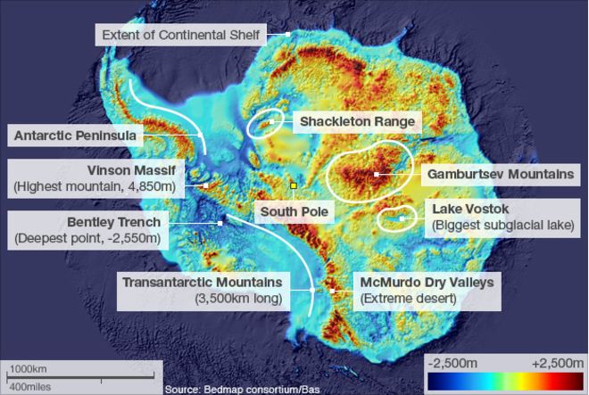
NASA has recently released a video showing the results of a study assembled by the British Antarctic Survey - Bedmap2 - which provides the most accurate look ever at the actual contours of the Antarctic landmass. Over 98% of this vast continent is normally covered with a thick layer of ice up to 3 kilometres thick, so such a study required millions of thousands of hours of flight datasets, taken from NASA's Operation IceBridge. Airplane surveys monitor changes in polar ice, and used Laser altimeters, RADAR, gravimeter and magnetometer to penetrate the thick ice layer and try to figure out what the land of Antarctica actually looks like.
Because the ice sheets covering Antarctica are constantly shifting and melting and freezing, the studies can help scientists understand major effects on weather and climate elsewhere. It is also a fascinating glimpse into an otherwise hidden landmass.
Related Blogs
Expeditions Online Newsletter
Sign up to be an Expeditions Online insider and receive info on exclusive deals, discounts and more!